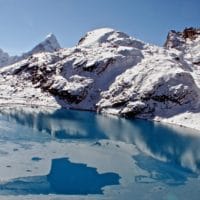
Imja Tso
Imja Tso is situated at a latitude of 27°59’17’’N and a longitude of 86°55’31’’E in the Khumbu region Everest of Nepal. It is at an altitude of 5010m above sea level. The lake is formed from the drains of Imja and Lhotse Shar Glaciers.
Initially, the lake was mapped as a small pond scattered in the year 1962. The total area of the pond was 0.03 sq. km. With the rapid melting of the Himalayas, the lake turned in the supraglacial lake by the year 1970s. By 2000 the area of the lake was 0.8 sq.km. Like this ratio, the area of the lake keeps on increasing; creating a big threat to swept all the village below. To prevent the outburst of the lake, many national and international bodies are trying to drain the millions of cubic meter from the lake and lower the level of water.